In 2018 my wife and I were on a similar road trip to visit various sites in the western United States. One of the places we planned to see was Horseshoe Bend. My goal was to photograph it at sunset. Unfortunately, I was a bit naive at the time and didn't plan well. I didn't expect large crowds as it was late in the autumn season when vacations have ended and fewer people travel. When we arrived, the large dirt parking lot was full and there were vehicles parked along the highway, at least a quarter mile before and after the entrance. Needless to say, disappointed, we returned to our hotel.
This time, as soon as we arrived in Page, Arizona from Zion National Park in Utah, I drove to Horseshoe Bend. it was just after 11 a.m. I didn't think the place would be that crowded that time of day as well as being in the 'shoulder' season. Although I still wanted to see it and photograph it at sunset, I felt we needed to scout it out and see how many people were present. I'm very happy we did.
I had seen many photos of Horseshoe Bend at sunset and my research showed me that when we would be visiting, the sun would set just to the left of directly behind it. Perfect!
The parking lot now is paved with proper pit toilets—lots of them—and it now costs $10 US to park. What I didn't realize is the overlook for Horseshoe Bend is a 3/4 mile (1.2k) walk from the parking lot. All downhill. Yep, all downhill. You know what that means. It is all uphill returning to the parking area. Off we set to see it!
As we walked on the wide fine gravel path to the overlook, the number of people present came into view. I made a photo of the people scattered along the edge of the 800 ft. cliff (below). I counted about 130 individuals in this photo. There were at least that or more walking to and from the overlook as well. Still, not too bad. There looked like there was plenty of room to make some photographs.
 |
| I counted about 130 individuals in this image along the rim of the cliff overlooking Horseshoe Bend. |
After we arrived at the overlook, some of which had steel railings to keep people from accidentally falling over that 800 ft. cliff (you know how crazy some people are trying to get selfies!), I was able to easily find a clear place to stand to make my photographs. I was thrilled that the sky was not clear blue with no clouds. In fact, I was so happy with the images I made that I decided I didn't need to come back at sunset, even though the sun would be setting in a spot for perfect composition. Again, I wasn't there to make portfolio photos but to finally see Horseshoe Bend and to make a couple of photographs representative of it. I'm pleased with the ones I made.
Other than seeing Horseshoe Bend and just doing some 'people watching' there wasn't much else to see or do so we started the 3/4 mile trek back up to our vehicle. It took me a few more minutes to walk back uphill than it did downhill. Lol. But it wasn't too bad, even for a couple of older folks such as my wife and I.
From Horseshoe Bend we drove into Page and found a wonderful local restaurant in which to have a very tasty lunch. When we travel we always try to eat at locally owned restaurants, strike up conversations with the servers and gather information that one normally can't find in books or on the internet. Our server was a Native American young lady and was very helpful with our questions about the area.
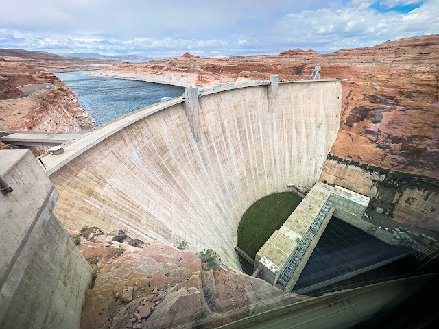
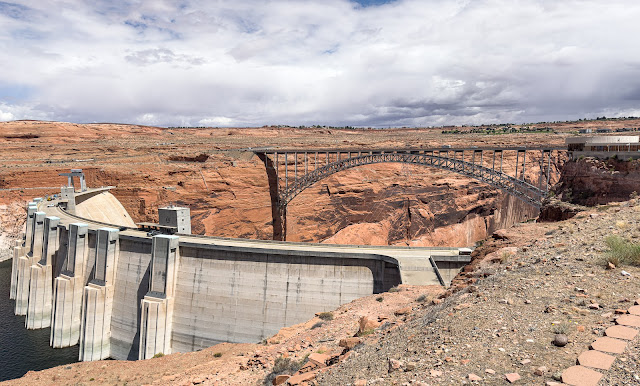
After lunch we decided to drive the few miles over to the Glen Canyon Dam and adjacent reservoir as we crossed the bridge over the gorge when we drove into town that morning and it was quite spectacular. I spent quite a bit of time in the visitor's center reading about the origin of the dam, how it was built and what economic and recreational benefits it brings to the area.
Just for reference, here are three record shots I made with my iPhone.
 |
| The 710 ft. (216m) dam was built from 1956-66 forms Lake Powell, which you can see just a bit of it behind it. This image was made through a window in the visitor's center. |
 |
| The adjacent bridge is 700 ft. above the river and is 1270 ft. (387m) long. |
 |
| Here you can see the other side of the dam, visitor's center on the extreme right and the adjacent bridge. |
After visiting the dam, it was late afternoon and we then checked into our hotel. The following day was another day I had been waiting for decades—our trip to and tour of Upper Antelope Canyon, the most famous of the slot canyons. Come back for that next post.
Thanks for looking. Enjoy!
Dennis A. Mook
All content on this blog is © 2013-2025 Dennis A. Mook. All Rights Reserved. Feel free to point to this blog from your website with full attribution. Permission may be granted for commercial use. Please contact Mr. Mook to discuss permission to reproduce the blog posts and/or images.

No comments:
Post a Comment